



Travel insights from a tour conductor — today’s destination: Kengamine, the summit peak of Mount Fuji in Shizuoka Prefecture.
Mount Fuji’s crater rim is ringed by eight peaks known as the Hasshinpo, and Kengamine is the tallest of them all. At 3,776 metres, it’s the highest point in Japan, and the stone marker reading “Nihon Saikōhō Fujisan Kengamine” (Japan’s Highest Peak, Mount Fuji Kengamine) draws a steady line of climbers waiting their turn for a photo. Of the four main climbing routes up Mount Fuji, the Fujinomiya Trail on the Shizuoka side covers the shortest distance to Kengamine.
| Item | Details |
|---|---|
| Name | Kengamine (Mount Fuji’s summit) |
| Climbing season | July 10 – September 10, 2026 (Fujinomiya 5th Station to summit) |
| Nearest trailhead | Fujinomiya 5th Station (2,400m) |
| Location | Summit of Mount Fuji, Fujinomiya City, Shizuoka Prefecture |
| Getting there | About 1 hour 20 minutes to 2 hours 5 minutes by bus from JR Fujinomiya Station or Shin-Fuji Station (during the private-car restriction period, a shuttle bus runs from Mizugazuka Park) |
Why the Fujinomiya Trail Isn’t the Route for a First Climb
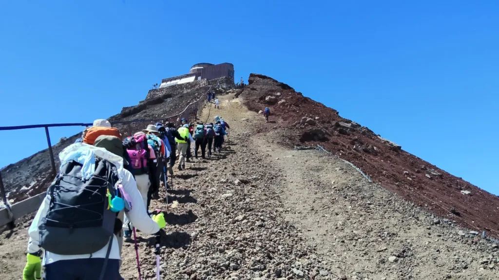
The Fujinomiya Trail may be the shortest route to the summit, but it still climbs nearly 1,400 metres from the 5th Station, with a steep, rocky ascent that continues almost to the New 7th Station. The ascending and descending paths share the same trail, so there’s little risk of taking a wrong turn, but that also means climbers heading up and down cross paths constantly around sunrise and during the day, which slows things down. Given these characteristics, the Fujinomiya Trail is generally considered a route for climbers with some prior experience, and it isn’t the best choice for a first attempt at Mount Fuji. First-timers are better served by the Yoshida Trail, which has a more developed path along with more huts and first-aid stations along the way. From Fujisan Chojo Fujikan, the hut nearest the summit, it’s roughly a 30-minute walk one way to Kengamine, so budget 60 to 90 minutes round trip once you factor in the queue for photos, a meaningful stretch to cover on legs that are already worn out from the climb.
Trailheads also require some groundwork before you set out. On the Shizuoka side, the official Shizuoka FUJI NAVI app walks you through the rules and etiquette, and you’ll need to pass a short quiz before paying the mountain entry fee. On the Yamanashi side, climbers go through a gear check and pay their own entry fee as well.
Attempting a “bullet climb,” summiting overnight without rest, raises the risk of altitude sickness, and there’s also a gate closure between 2pm and 3am the following day for anyone who isn’t staying at a mountain hut. Building in a more relaxed schedule pays off.
Even from the 5th Station, at 2,400 metres, the air is noticeably thinner than at sea level, and plenty of climbers start feeling headaches or shortness of breath somewhere past the 9th Station. The rock around Kengamine itself is loose scoria that gets slippery on the way down, so proper gear, trekking poles and sturdy boots with thick soles, makes a real difference.
Home to the World’s Highest Weather Station
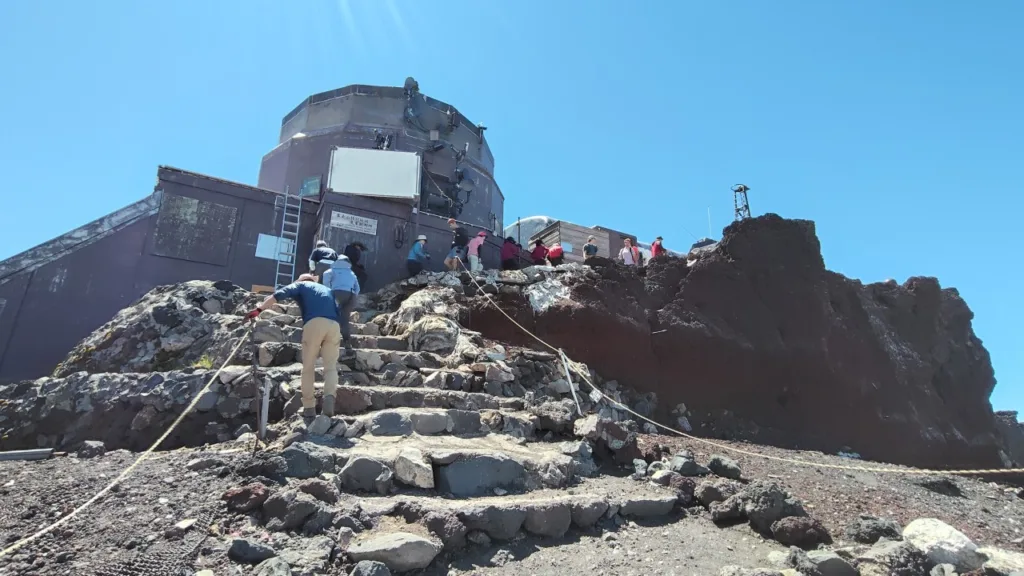
Kengamine’s history is tied closely to weather observation. In 1932 the Central Meteorological Observatory set up a temporary station at Higashi-Yasugawara, on the crater’s southeastern rim, then moved it to Kengamine itself in 1936 once officials realised the summit gave better wind readings. At the time, it was the highest permanently staffed weather station in the world, and the data it gathered helped researchers map the jet stream passing over Japan and build a foundation for high-altitude meteorology.
In 1964, the year of the Tokyo Olympics, a weather radar was installed at the summit to catch typhoons approaching from the south long before they made landfall. As satellite technology advanced, the radar dome was retired after 37 years of service and dismantled in 2004; it’s now on display at a hands-on museum in Fujiyoshida, Yamanashi. The observatory itself became a special regional weather station in 2008, and an NPO still borrows the facility each summer for atmospheric research.
A Small Puzzle Behind the 3,776-Metre Figure
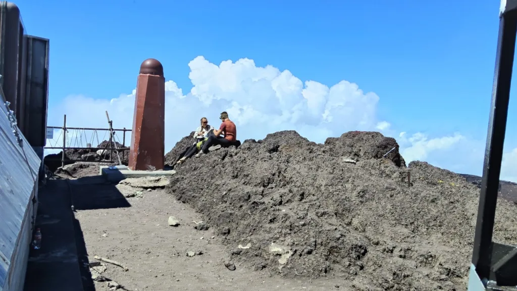
Kengamine’s exact elevation is a small puzzle in itself. The second-order triangulation point named “Fujisan,” set by Japan’s Geospatial Information Authority, sits at 3,775.63 metres, while the true high point, a rocky outcrop just to its north, measures 3,776.24 metres. Both round to 3,776m, which is why that figure is the one everyone knows, but it means the marker post itself isn’t actually standing on the highest ground, a detail that surprises a lot of visitors. There’s also an electronic reference station behind the post whose antenna sits even higher, at 3,777.5 metres, so depending on exactly where you measure, “Japan’s highest point” can shift by a metre or so.
Why the Summit Still Has No Official Prefectural Border
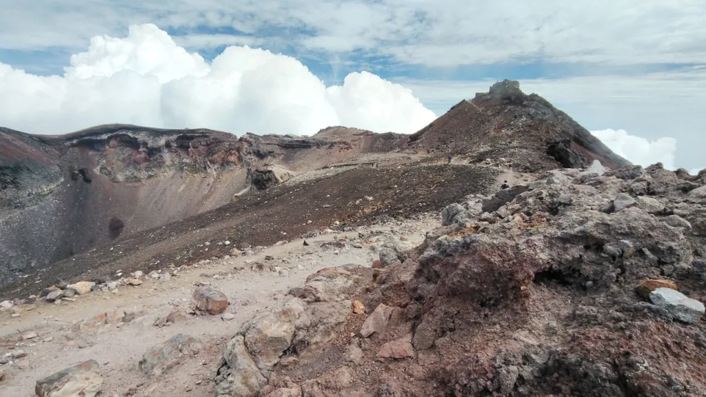
Mount Fuji’s summit carries a lesser-known piece of history. The mountain straddles Yamanashi and Shizuoka prefectures, but the border around the summit and Kengamine itself has never officially been settled. Land above the eighth station is treated as shrine grounds belonging to Fujisan Hongu Sengen Taisha, a legacy of a donation made by Tokugawa Ieyasu in the Edo period, and it doesn’t fall under either prefecture’s jurisdiction. Even the address used by the summit post office, “Awakura, Fujinomiya City, Shizuoka,” is a convenience for wayfinding, not a legal determination of the border.
The standoff goes back centuries. The Edo-era gazetteer Kai Kokushi already noted that “above the eighth station, there is no border between the two provinces.” In 1897 the Imperial Household Ministry’s land office attempted a survey, but Shizuoka pushed for the eighth station as the boundary while Yamanashi argued for a line at the summit, and neither side backed down. In 1951 the two prefectural governors agreed simply not to contest the summit’s border going forward, and when the debate resurfaced around Mount Fuji’s UNESCO World Heritage listing in 2013, both governors reaffirmed that same position. Kengamine remains, to this day, a peak that belongs to no prefecture in particular.
There’s a related bit of trivia climbers often share: you haven’t truly stood on Japan’s highest point unless you’ve walked the crater rim to Kengamine itself. Climbers who summit via a Yamanashi-side trail emerge on the opposite side of the crater, so reaching the true high point means circling the rim, known as Ohachi-meguri.
A Sacred Peak in Mount Fuji Worship
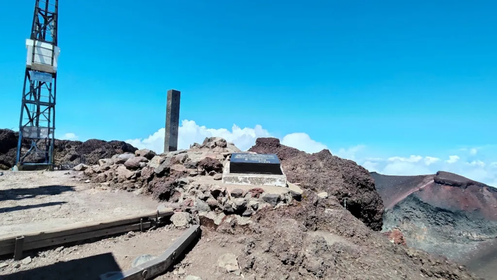
Kengamine also carries deep religious significance. Everything above the 8th station is considered the sacred body of Fujisan Hongu Sengen Taisha, and pilgrims from Edo-era Fuji-ko confraternities have climbed toward the summit for generations. To the west of Kengamine lies Osawa Kuzure, a vast erosion scar where debris washed down eventually feeds the Uruigawa River on its way to Suruga Bay. Near the summit stands a stone monument inscribed with a haiku by the poet Seishi Yamaguchi, capturing the sheer drop of Fuji’s cliffs.
The One Experience You Can’t Have Anywhere Else in Japan
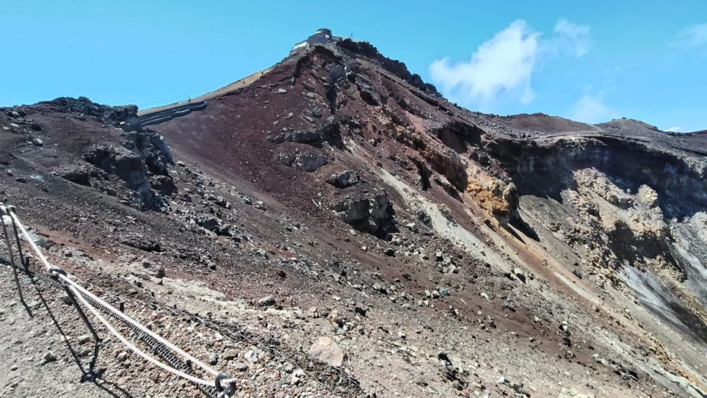
Kengamine’s biggest draw is simple: it’s the only place in the country where you can stand at the absolute highest point. On a clear day, the deep blue of Suruga Bay and the Izu Peninsula stretch out below, and the light here at sunset looks different from anywhere else on the mountain. Standing at the marker, you can look across the crater to the Yoshida Trail’s summit area, where Kusushi Jinja shrine sits, and get a real sense of just how vast Mount Fuji actually is.
Of the four routes, Fujinomiya gets you closest to Kengamine, which means less walking once you’re already at the top. Climbers coming up the Yoshida Trail have to circle nearly the entire crater rim to reach Kengamine, whereas from Fujisan Chojo Fujikan on the Fujinomiya side, it’s about a 30-minute walk.
Experiences Only the Summit Can Offer
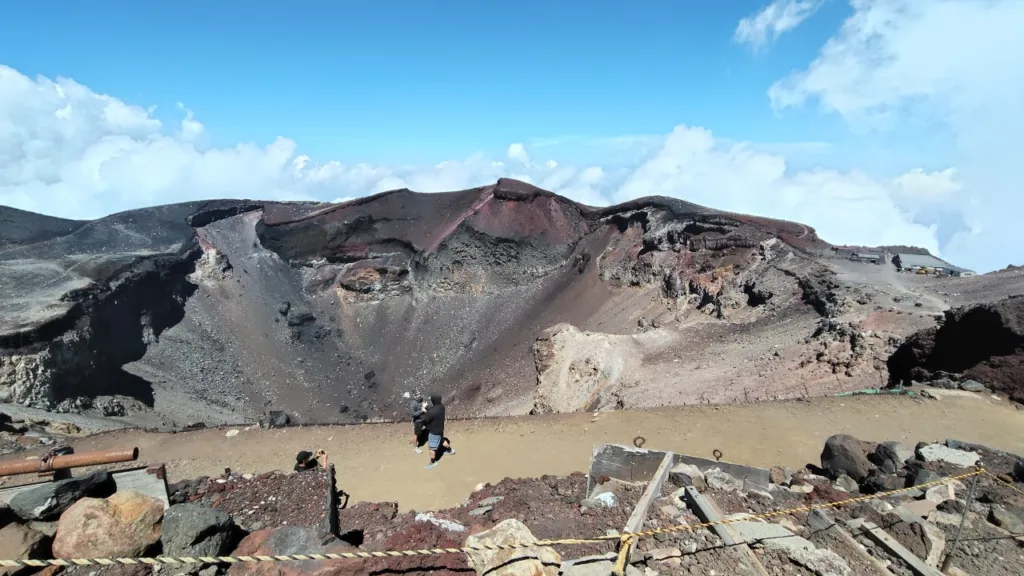
Ohachi-meguri, the roughly 90-minute walk around the crater known as Dainaiin, is a favourite among climbers who reach Kengamine. It’s a chance to take in the shapes of the surrounding peaks and get a feel for how the crater was formed.
Fujisan Chojo Fujikan is one of the few huts on the mountain that will stamp your climbing certificate with a dated commemorative seal, and plenty of climbers stop by to mark the achievement. On a clear day with no cloud cover you can sometimes see as far as the Boso Peninsula, and many climbers time their overnight stay to catch sunrise from here.
From the hut at the 9.5th Station and Mannenyuki Sanso at the 9th Station, the walk up to the summit averages about an hour, and climbers often time their departure backwards from sunrise. Picking your way through dim, rocky terrain before dawn, watching the sky slowly lighten as you near the top, is a distinctly Fujinomiya-route experience.
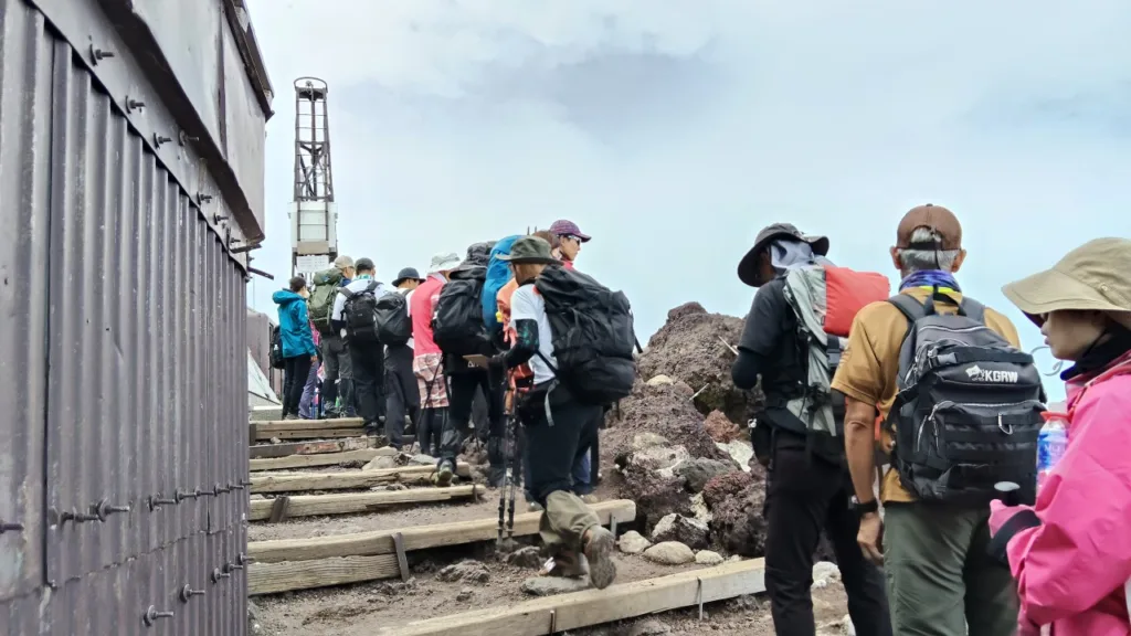
The marker at Kengamine gets crowded with climbers waiting for photos right from sunrise onward. Queues run especially long on weekends, public holidays, and around the Obon week in mid-August, and at peak times the line can stretch all the way down to the base of Uma-no-se, the steep final slope just below Kengamine. Uma-no-se is already a tricky, slippery stretch underfoot, so it’s worth building the wait time into your plan.
Nearby Spots
A short walk from Kengamine opens up a handful of sights worth the detour, most of them easily folded into an Ohachi-meguri loop, so plenty of climbers spend time exploring the summit area beyond the round trip to the marker itself.
Fujisan Hongu Sengen Taisha Okumiya
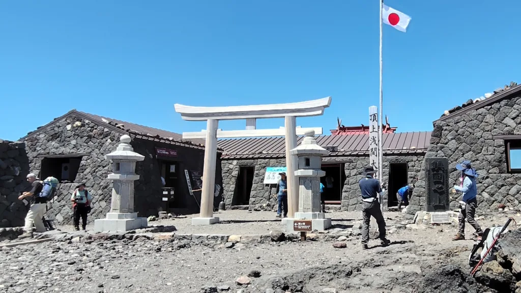
At the top of the Fujinomiya Trail sits the Okumiya, the inner shrine of Fujisan Hongu Sengen Taisha. Everything above the 8th station is considered the shrine’s grounds, and during the climbing season a priest is stationed here to offer talismans and charms. The shrine’s main festival falls on August 15th; once the mountain closes for the season in September, the shrine stands empty until the following summer.
Mount Fuji Summit Post Office
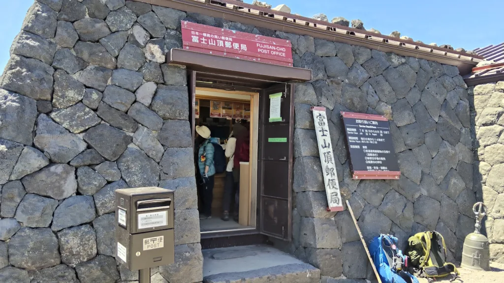
Inside the Okumiya’s shrine office is the highest post office in Japan. In 2026 it’s open from July 10th to August 20th, 6am to 2pm, and you can mail a letter or postcard straight from the summit, or have your climbing certificate stamped with Mount Fuji’s distinctive commemorative postmark. The post office traces back to 1906, when it first opened as the Fujisan Post Office, and it’s operated seasonally each summer ever since.
Hakusandake
North of Kengamine across the crater sits Hakusandake, home to a second-order triangulation point called “Fuji Hakusan” and the second-highest peak among the Hasshinpo. It sits right along the Ohachi-meguri route, so most climbers who make it to Kengamine take it in as part of the same loop.
Kusushidake, Izudake and the Other Hasshinpo Peaks
Rounding out the eight peaks are Kusushidake, known as a sunrise viewpoint, and Izudake, where steam vents were reportedly spotted just after the 1923 Great Kanto Earthquake. Circling Dainaiin, the crater at the centre of the summit, past all these peaks is what makes up Ohachi-meguri, and pairing it with the walk to Kengamine gives a much fuller sense of the crater’s shape and Mount Fuji’s scale.
Kaminari-iwa and Tora-iwa
Along the rim between Kengamine and Hakusandake sits Kaminari-iwa (Thunder Rock), named for the storm clouds that tend to roll in from that direction, and its surface is covered in fine cracks up close. Tora-iwa (Tiger Rock) juts out over Dainaiin and gets its name from its resemblance to a crouching tiger. Both are visible along the Ohachi-meguri path, though parts of the outer rim are occasionally closed due to rockfall risk, so it’s worth checking current trail conditions before setting out.
Where to Stay Near the Fujinomiya Trailhead
For a stay before or after the climb, the town around Fujinomiya Station and the highland areas with Mount Fuji views both make convenient bases. If you’re catching an early bus, somewhere near the station cuts down on morning stress; if you’d rather spend the night before unwinding properly, the hot-spring hotels and lakeside resorts a bit further out are worth considering too.
Fujinomiya Fujikyu Hotel
Fujinomiya Fujikyu Hotel sits just a minute’s walk from Fujinomiya Station, and during climbing season the bus to the new 5th Station departs right from the terminal in front of the hotel. Rooms have a warm, wood-toned feel, and the free breakfast buffet features local specialities like Fujinomiya yakisoba and Asagiri milk.
Super Hotel Fujinomiya
About seven minutes by car from the station, Super Hotel Fujinomiya, home to the natural hot spring Sakuya no Yu, offers separate baths for men and women along with a free breakfast buffet. Shiraito Falls and Fuji Milkland are both within easy reach, making it a solid base before or after a climb.
Kyukamura Fuji
On the shore of Lake Tanuki, Kyukamura Fuji is known for Mount Fuji views from every room, including the “upside-down Fuji” reflected on the lake’s surface, visible from the guest rooms and restaurant alike. It’s about 45 minutes from Fujinomiya Station by local bus, but the quiet, scenic setting suits travellers who want to slow down before or after the climb.
Climbing with a Tour Conductor
Kengamine rewards good timing, and getting the timing right on Mount Fuji, entry procedures, hut check-ins, weather windows, sunrise departures, is easier with someone managing the itinerary on the ground. A tour conductor doesn’t lead the climb or set the pace; that’s the operator’s role. What a tour conductor handles is the logistics around it: confirming hut reservations, coordinating bus and shuttle connections during the private-car restriction period, and stepping in with interpretation if a language barrier comes up at a hut check-in counter or on the mountain entry app.
That support matters most when something goes wrong. Sudden weather changes, a missed bus connection, a climber needing to turn back early, these are exactly the moments where having someone handle emergency rebooking and communication takes the pressure off the group and keeps the day moving. It’s not about being guided up the mountain; it’s about knowing the practical side of the trip is being taken care of, so you can focus on the climb itself.
For travellers planning a Mount Fuji ascent, arranging a dedicated tour conductor through tours.e-stay.jp is worth considering, particularly for overnight hut stays or parties that include first-time climbers, who are encouraged to take the Yoshida Trail rather than Fujinomiya.
Final Thoughts
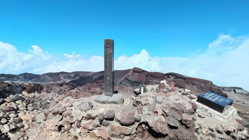
Kengamine is the tallest of Mount Fuji’s eight summit peaks and the one true high point in Japan, a genuinely singular thing to stand on. Climbers with some prior experience can reach it fastest via the Fujinomiya Trail on the Shizuoka side, though it still calls for proper preparation: completing the entry procedures in advance, packing the right gear, and building enough time into your plan for Ohachi-meguri, a stop at the Okumiya shrine, or the queue at the summit marker itself.
Knowing the history behind the old weather station, the unresolved prefectural border, and the layers of religious significance the mountain carries, tends to make standing at that marker feel like more than just a photo opportunity. For your stay before or after the climb, somewhere close to the bus terminal, like Fujinomiya Fujikyu Hotel near the station, keeps the logistics simple, while a lakeside stay at Kyukamura Fuji is worth it if you’d rather spend the night taking in the view of Mount Fuji itself.