



Travel insights from a tour conductor — today’s destination: the Ohachi Meguri, the crater-rim circuit at the very top of Mount Fuji, reached from the Shizuoka side of the mountain.
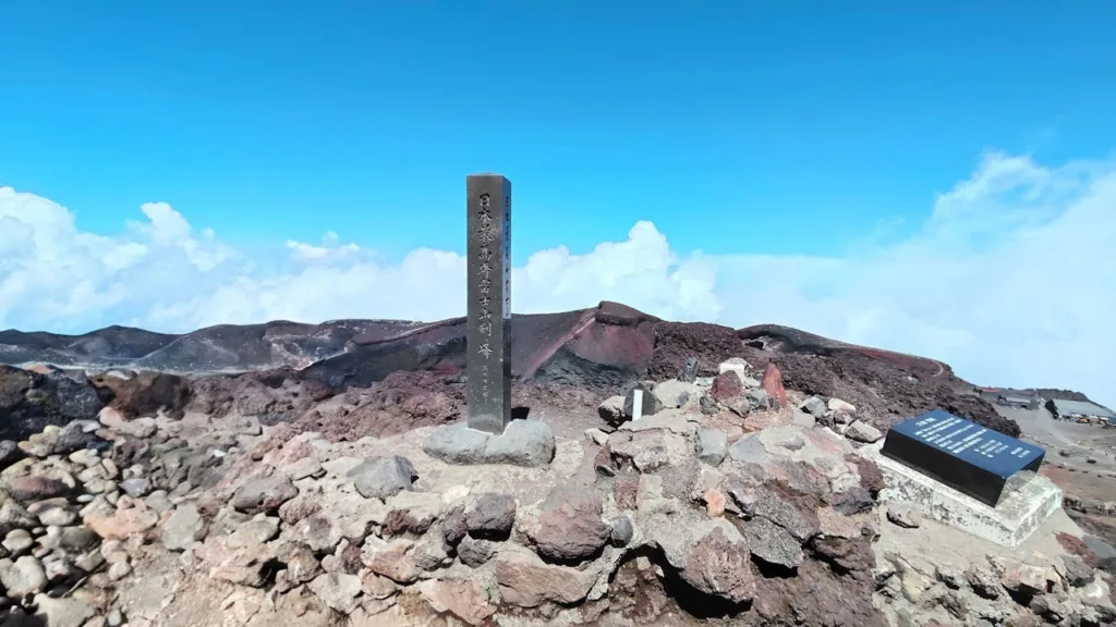
At the summit of Mount Fuji sits a crater more than 780 metres across and over 200 metres deep. Walking its rim from start to finish is what’s known as the Ohachi Meguri, literally “the bowl circuit.” Pilgrims of the old Fuji-ko faith used to complete this loop clockwise after paying their respects at the summit shrine, and the tradition still shapes how climbers approach the crater today. The route takes in Kengamine, Japan’s single highest point, along with seven other peaks that ring the crater and carry centuries of religious history.
| Item | Details |
|---|---|
| Name | Ohachi Meguri (crater-rim circuit) |
| Distance | Roughly 3 km |
| Time required | About 90 minutes |
| Starting point | The summit of any climbing trail (near Kusushi Shrine on the Yoshida/Subashiri side, or near the Okumiya shrine on the Fujinomiya/Gotemba side) |
| When it’s possible | Only while the climbing trails are open; not accessible when the summit is under snow |
Trail seasons and where you start
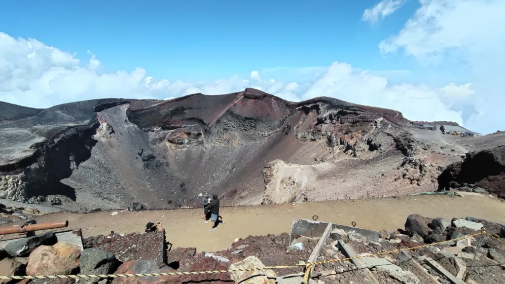
The Ohachi Meguri can only be walked while the summit trails are open. In a typical year, the Yoshida and Subashiri trails open in early July, while the Fujinomiya and Gotemba trails follow around July 10th, with all four closing in early September. Which trail you climb determines where you begin the loop. Coming up via Yoshida or Subashiri, you’ll start near Kusushi Shrine; via Fujinomiya or Gotemba, you’ll start near the Okumiya shrine. Either way, one full lap around the crater rim brings you past all the main sights, Kengamine included.
Before you set out
The path runs along the crater’s edge, with a drop-off on one side and the crater itself on the other. Guardrails only cover part of the route, so strong wind, rain, or fog can turn a loose rock underfoot into a real hazard. If the weather turns while you’re up there, the safest move is to turn back rather than push on. Trail markers are sparse too, so it’s worth checking your position with a map or GPS app as you go. The loop itself covers only about 3 km round trip, but at over 3,700 metres, the altitude makes it feel far more tiring than the distance suggests.
Where the name comes from
There are two competing stories behind the name Ohachi Meguri. One traces it to the eight peaks ringing the crater, known collectively as Hasshinpo — the “Eight Sacred Peaks” — which gave rise to the earlier name Ohachi Meguri (literally “circling the eight”), later shortened to today’s form. The other simply points to the crater’s shape, which resembles a large mixing bowl, or “hachi.” Either way, the route has been treated as a place of pilgrimage for a very long time.
No one knows exactly when the term Hasshinpo first came into use, but by the time Fuji-ko pilgrims were climbing in large numbers, the circuit around the crater was already an established ritual. Climbing Mount Fuji in that era was steeped in Buddhist practice, and each of the eight peaks was given the name of a Buddhist deity. At the centre of it all, the crater itself was assigned to Dainichi Nyorai, with the surrounding peaks representing figures such as Amida Nyorai and Yakushi Nyorai — a scheme recorded in pilgrimage diagrams dating back to the late 17th century. This set of eight bodhisattvas and buddhas, plus the central Dainichi, became known as Hachiyo Kuson, “eight petals, nine venerables.” After the Meiji-era separation of Buddhism and Shinto, the peaks were renamed with the Shinto titles used today, though traces of that older layer of belief remain scattered across the summit. Even the octagonal handle of the traditional climbing staff sold on the mountain is said to reflect the eight peaks.
The clockwise direction of the walk has its own backstory. Pre-Meiji climbing culture leaned heavily on Buddhist practice, and circling a sacred site clockwise — a custom known as unyo — was the accepted way to show reverence. That’s the origin of the clockwise tradition still followed today, though plenty of modern climbers go the other way to avoid tackling Umanose, the steep, loose-gravel slope just below Kengamine, on the uphill side.
Eight peaks around the crater
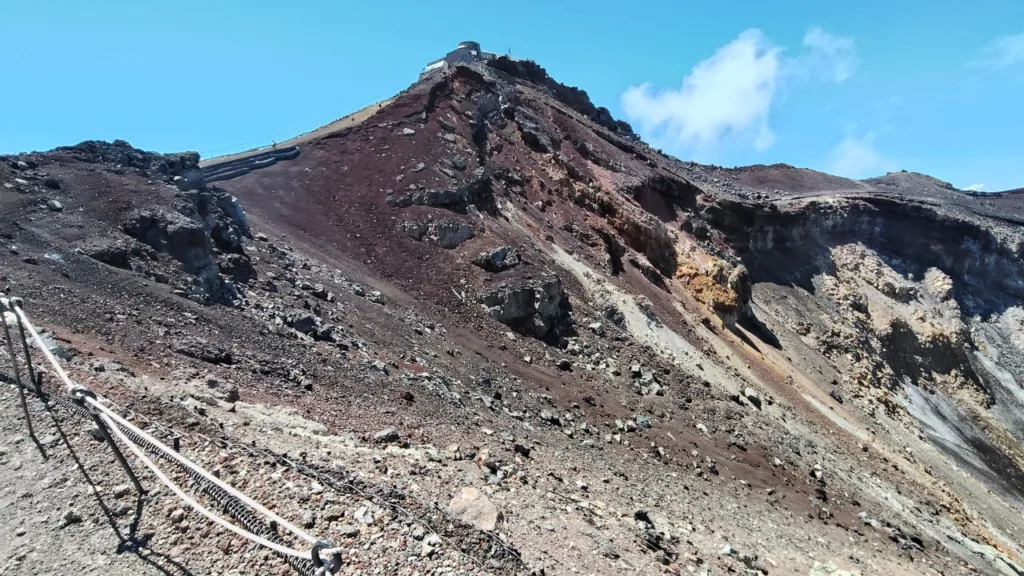
Hasshinpo refers to the eight most prominent points on the crater rim. Kengamine, at 3,776 metres, is the best known as Japan’s highest point, but the other seven each have their own name and history: Hakusandake (also called Shaka-ga-take, 3,756.2 m), Kusushidake (Yakushi-ga-take, 3,725 m) near Kusushi Shrine, Dainichidake (Asahidake, 3,735 m), a favourite spot for watching sunrise, Izudake (Amida-ga-take, 3,749 m), where steam was reportedly seen shortly after the 1923 Great Kanto Earthquake, Joujudake (Seishi-ga-take, 3,733 m), Komagatake (Sengen-ga-take, 3,722 m) near the Fujinomiya trailhead, and Mishimadake (Monju-ga-take, 3,734 m). Sources vary slightly on which peaks count among the eight, but all of them rise from the rim of the crater known as Ounain.
These days, for safety reasons, the standard route bypasses the actual summits of most peaks and instead follows a path just below them. Even so, looking up at the ridgeline of all eight from the crater rim gives a real sense of both the volcano’s structure and the long history of pilgrimage that shaped this walk.
Sacred springs and volcanic features along the way
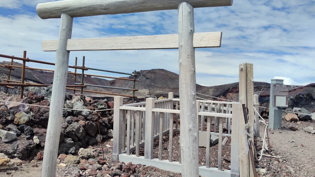
The crater itself, called Ounain, sits at the centre of the loop. Also known as Kakurenomiya, it’s considered the dwelling place of the mountain deity and is off-limits to visitors — you can walk the rim but not enter the crater floor. Its name draws on Buddhist and Shinto cosmology alike, and in the Edo period, pilgrims would toss offerings down into it from above. Below Kaminariiwa (Thunder Rock), a smaller crater called Ko-Ounain opens up, also known as Amida-ga-kubo after the Amida Buddha once associated with it. Nearby, a rock formation called Shaka-no-Wareishi (“Buddha’s split stone”) marks another stop on the route. At the base of Hakusandake, meltwater from the surrounding peaks surfaces at a spring called Ginmeisui, long revered as sacred water and marked with a small shrine. A second spring, Kinmeisui, is found near Kusushi Shrine. Kaminariiwa itself takes its name from the direction thunderstorms tend to roll in from, while Toraiwa (Tiger Rock) is named for its resemblance to a crouching tiger — small details that add texture to the walk as you make your way around.
A 360-degree summit view
The real payoff of the Ohachi Meguri is the view: a full 360-degree panorama from the highest point in Japan. On a clear day, you can pick out Yarigatake in the Northern Alps far in the distance. As you circle the rim, the sea of clouds, the surrounding ridgelines, and the plains far below all shift with every step, each turn offering a slightly different face of the mountain. Standing at Kengamine, with the crater dropping away on one side, delivers a sense of scale that photos never quite capture.
Sunrise draws the biggest crowds, with the area around Kusushi Shrine and Dainichidake filling up as climbers wait for first light. Umanose, the final push up to Kengamine, is a loose, steep slope where footing can be tricky in either direction, so it pays to time your approach around the crowds rather than fight through them. Weekends and the days around Obon in mid-August tend to be the busiest, and because the path along the crater rim is narrow, passing other groups can eat up more time than you’d expect. Building some slack into your schedule makes it much easier to actually enjoy the views instead of rushing past them.
Nearby Highlights
A few landmarks sit directly on or near the Ohachi Meguri route, each worth a closer look on the day.
Kengamine
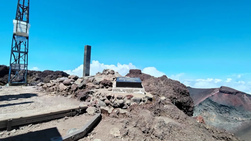
The highest point of the entire loop and of Japan itself, Kengamine once housed a weather observatory that played a real role in the country’s meteorological history. The view from the top, after the final climb up Umanose, is the high point of the whole circuit in more ways than one.
Fujisan Hongu Sengen Taisha Okumiya
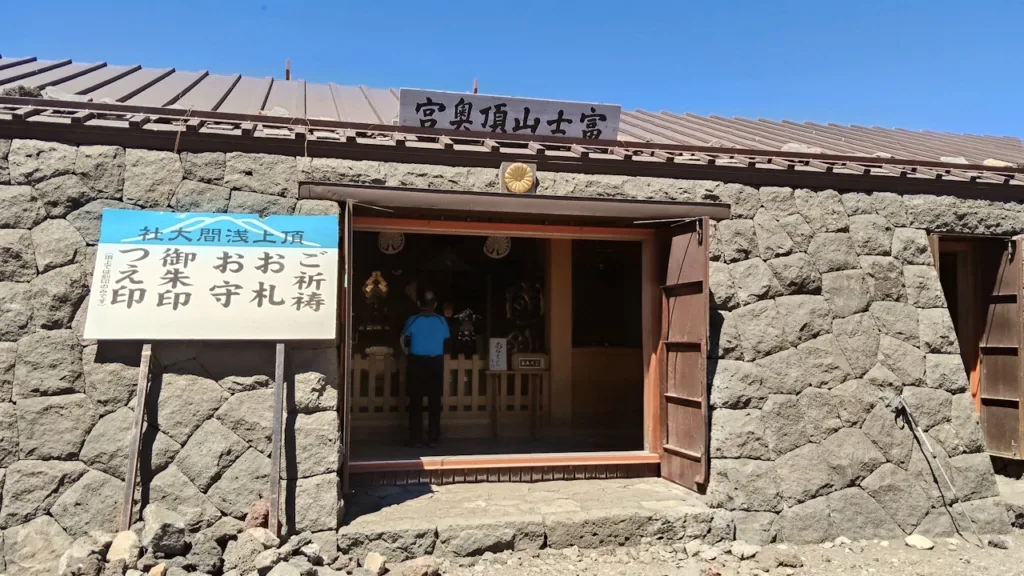
Sitting at the top of the Fujinomiya trail, this shrine oversees the sacred ground above the eighth station. During the climbing season it’s staffed by resident priests, and the quiet, formal atmosphere here feels strikingly out of place at nearly 3,700 metres above sea level.
Kusushi Shrine
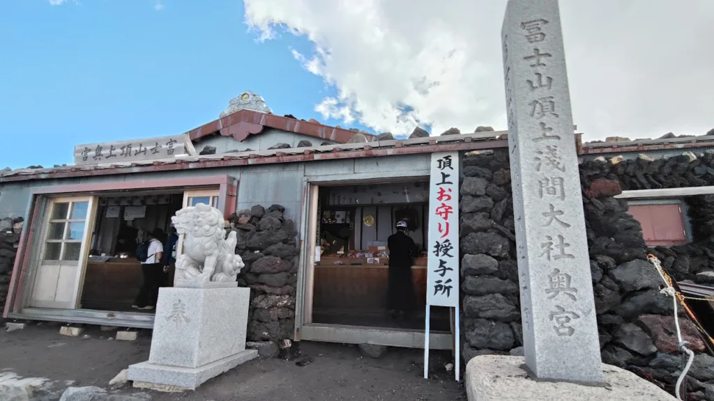
Perched at the top of the Yoshida and Subashiri trails, Kusushi Shrine is a lively gathering point for climbers waiting on the sunrise. Stalls line the area around it, giving this stretch of the summit a distinctly busy, festival-like energy compared to the quiet stretches elsewhere on the rim.
Where to Stay
Fujinomiya makes a convenient base for climbers heading to or from the Ohachi Meguri, whether staying the night before an early start or resting up afterwards.
Fujinomiya Fujikyu Hotel
Just a two-minute walk from Fujinomiya Station, this hotel sits right by the bus terminal that runs services up to the fifth station during climbing season, making it an easy base for the trailhead. Its free breakfast buffet leans into local flavours, including Fujinomiya’s famous yakisoba noodles and milk from the nearby Asagiri highlands.
Natural Onsen Sakuya no Yu Super Hotel Fujinomiya
For unwinding after the climb, this hotel’s natural hot spring, drawing on water rich in sodium and calcium, is well suited to soothing tired legs and sore muscles. A free breakfast buffet is included as well.
Kyukamura Fuji
Set on the shore of Lake Tanuki, this hotel offers views of Mount Fuji from every guest room. Its slightly alkaline natural hot spring is a good way to ease into a slower pace after a long day on the mountain.
Why Climb With a Tour Conductor
Mount Fuji’s summit trails are demanding even before you factor in the Ohachi Meguri itself, and a tour conductor takes the logistics off your plate so you can focus on the climb. From coordinating trailhead transport and hut reservations to managing the day-by-day schedule around weather and altitude, a tour conductor handles the itinerary end to end, adjusting plans on the fly if conditions change or an unexpected issue comes up along the way.
Language is rarely a small thing at 3,700 metres, and having someone on hand for interpretation, whether at a mountain hut, a shrine, or in an emergency, removes one more variable from a trip that already has plenty of them. If a flight needs rebooking, a transfer falls through, or plans need adjusting mid-trip, that’s exactly the kind of situation a tour conductor is there to manage, working alongside the local operators who handle the on-the-ground arrangements. The result is a trip where the practical details are looked after, leaving more attention for the crater rim, the sunrise, and the view from the top of Japan.
Find out more about touring Mount Fuji and beyond with a dedicated tour conductor at tours.e-stay.jp.

In Summary
The Ohachi Meguri brings together Japan’s highest point, seven other storied peaks, and a layer of religious history that goes back centuries, all wrapped into a single loop around Mount Fuji’s summit crater. Conditions can change fast up there, so caution matters as much as enthusiasm, but on a clear day the payoff is a 360-degree view and a crater rim lined with centuries of pilgrimage history. Fujinomiya’s hotels, from the Fujikyu near the station to the lakeside Kyukamura Fuji, make a solid base for climbers timing their ascent around this iconic summit walk.